The National Hurricane Center sent out a message this week advising people along the Texas coast to monitor a tropical storm that died on Monday in the central Caribbean, but has gained strength and is predicted to make landfall in the middle of the Texas coast as a Category 3 hurricane sometime this evening or Saturday morning. Yesterday afternoon, the storm’s winds were rated at 80 mph and the middle of the Texas coast was placed under a hurricane warning.
As the storm, now officially named Hurricane Harvey, churned toward Texas, Gov. Greg Abbott pre-emptively declared a state of disaster and issued a disaster proclamation on Wednesday in 30 counties on or near the coast to speed deployment of state resources to any areas affected. Those counties include Aransas, Austin, Bee, Calhoun, Chambers, Colorado, Brazoria, DeWitt, Fayette, Fort Bend, Galveston, Goliad, Gonzales, Harris, Jackson, Jefferson, Jim Wells, Karnes, Kleberg, Lavaca, Liberty, Live Oak, Matagorda, Nueces, Refugio, San Patricio, Victoria, Waller, Wharton and Wilson. Abbott has activated about 700 members of the state National Guard ahead of Hurricane Harvey making landfall. Military helicopters are on standby in Austin and San Antonio in preparation for search and rescues and emergency evacuations.
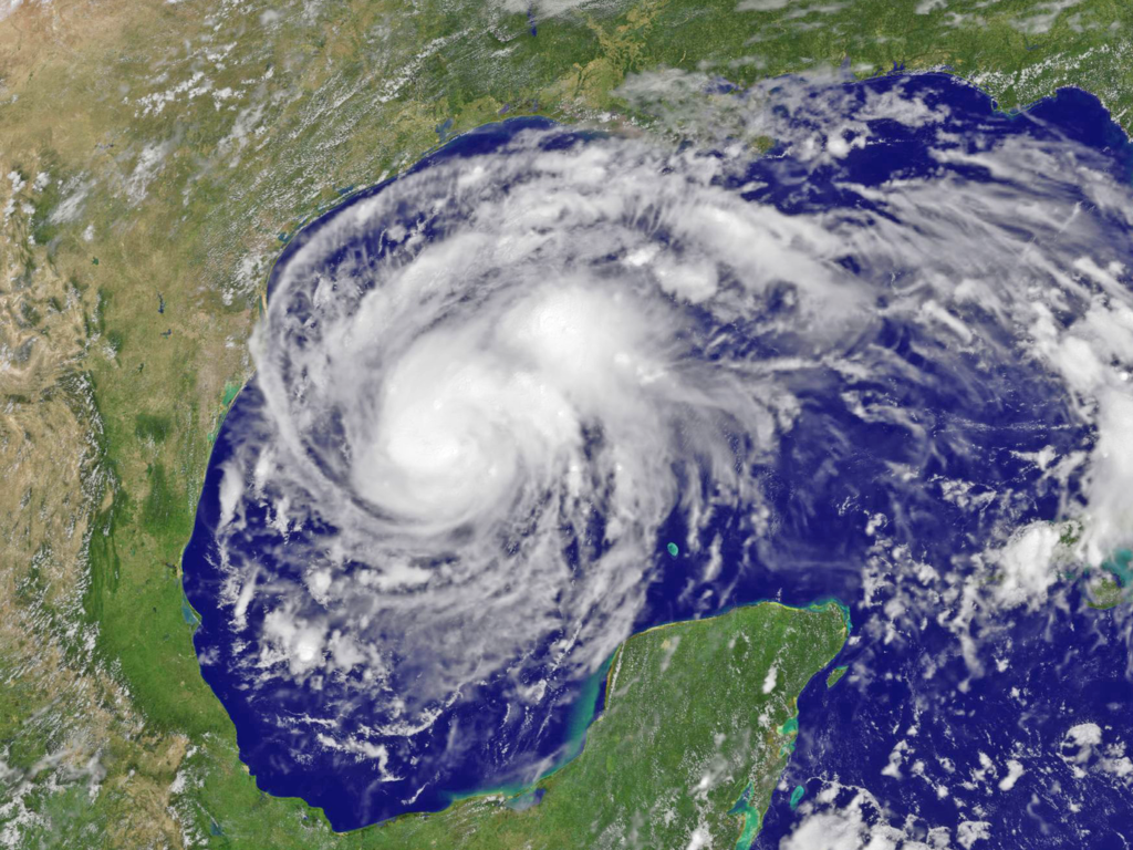
Hurricane Harvey the morning of Aug. 25. Photo courtesy of the National Oceanic and Atmospheric Administration.
Harvey is already affecting back-to-school schedules across southeast Texas. Several school districts, colleges and universities canceled or announced an early release from classes yesterday and most of them are closed today. Many school officials have already made closure decisions for next week while others are waiting to see what Harvey does over the weekend before making closure announcements for next week.
Businesses also have had to close up shop due to evacuations, safety concerns and the possibility of significant flooding. Along the coast and out in the gulf are oil refineries and offshore oil and gas platforms that have had to temporarily close down production. Roughly 30 refineries are scattered along the Texas coast to Louisiana. Combined, the refineries process an estimated 7 million barrels of oil every day to make gasoline, diesel and other products. Just under 10 percent of offshore U.S. Gulf of Mexico crude output capacity was shut down on Thursday, government data showed. These shutdowns will have a significant impact on crude oil imports into the Texas Gulf Coast, resulting in refineries cutting crude rates. There will also be a chain reaction of petroleum product exports impacting supplies into Mexico. Prices at the pump will also rise.
The last major hurricane to hit Texas was Ike in 2008. The predictions for Harvey once it enters Texas has been ever changing, and the current prediction for Harvey is that the path of the storm is expected to hit the middle Texas coast. After that, Harvey will likely stall over the state. The storm will make landfall late Friday or early Saturday and is now a Category 2 hurricane. It could be upgraded to a Category 3 by the time it makes landfall.
In June, the Texas Division of Emergency Management (TDEM) developed and sponsored a series of exercises to test the state’s hurricane preparedness program. The full-scale exercise, called Hurricane Charlie, took place over a 9-day period. The scenario was that a Category 4 Hurricane was predicted to make landfall in the Houston-Galveston-Sabine Lake region. Volunteers took part in evacuations which involved being banded and entered into the Emergency Tracking Network (ETN). The ETN is a partnership between city, county and state governments to track evacuees that cannot get to a designated shelter on their own. It greatly reduces the chances of someone getting lost or misplaced during an emergency.
This system will give shelter staff the ability to coordinate people and pets across several locations in real time. They can scan a drivers’ license or log in information that will produce a wristband. The wristband will be issued to the evacuee with a barcode on it.
During the TDEM exercise, participants stayed at shelters, brought service animals and pets and were brought back to their point of origin once it was safe to go home. The exercise was supported and evaluated by the Federal Emergency Management Agency’s (FEMA) National Exercise Division. The exercise also provided several jurisdictions the opportunity to test the information provided through the State of Texas Emergency Assistance Registry (STEAR). The STEAR program is a free registry that provides local emergency planners and responders with additional information on the needs within their community. Those that need assistance to evacuate should register with the Texas 211 system, a database that will keep information on a person and if they need assistance to evacuate, they call 211.Those that need assistance from the state in order to evacuate will be in the ETN system regardless if they are registered with the Texas.
When a disaster does hit Texas, the state, cities and counties have the opportunity to apply for grants to make critical repairs.
The Department of Housing and Urban Development (HUD) has allocated an additional $178.5 million of funding to support recovery in areas across several states hit hardest by severe flooding in 2015 and 2016. The grants are provided through the department’s Community Development Block Grant – Disaster Recovery (CDBG-DR) Program. Together with previously allocated grants, HUD’s investment to hard-hit areas now totals almost $946.7 million.
For 2016 disasters, HUD is releasing disaster recovery funds of $9.8 million to Texas. For 2015 disasters, Texas was granted an additional $8.2 million in disaster recovery funds for total combined allocations of $74.6 million. Disaster recovery funds of $978,000 were granted to San Marcos, resulting in combined allocations to date of $33.8 million. The grants support housing redevelopment, business assistance and infrastructure repair. The funds will be used by state and local governments to target the most impacted areas.
Another disaster assistance provider is the Federal Emergency Management Agency (FEMA). One example of FEMA assisting Texas is partial funding for the Buffalo Springs Drive bridge repair, which was damaged by floods in spring 2016. FEMA is funding roughly $1.4 million in repairs, while the remaining cost will be funded by grants from the Community Development Block Grant disaster relief program and Texas General Land Office. The bridge repair is expected to be completed in February 2018.
The Texas Water Development Board also provides disaster assistance through an assortment of grants and loans. The TWDB offers a variety of cost-effective loan and grant programs that provide for the planning, acquisition, design and construction of water-related infrastructure and other water quality improvements. Other useful emergency management sources for cities and counties in Texas include:
Texas Emergency Operations Centers throughout the region:
http://www.tdms.org/county.aspx
Texas Department of Emergency Management Situation Reports: https://www.dps.texas.gov/dem/sitrep/default.aspx
Texas Emergency Management Executive Guide FY 2017 Edition:
http://www.dps.texas.gov/dem/GrantsResources/execGuide.pdf
Strategic Partnerships, Inc. (SPI) is leading the way in the rapidly expanding area of public-private partnerships. Learn about SPI’s service offerings in both the public and private sectors by contacting them today.