 Light Detection And Ranging (LiDAR) technology is becoming a common component in our daily lives even though the term remains unfamiliar to many people.
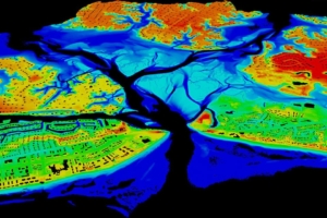
LiDAR uses a beam of airborne laser light to map out ranges in 3-D. These images are integral to construction, engineering, and geographical information systems industries. LiDAR technology is especially useful for many services performed by government agencies as well.
Within California, projects oriented around the two main categories of LiDAR technology— topographic and bathymetric — are on the launch pad for 2022. Bathymetric technology beams light through water to map underwater terrain. It offers high value and distinct advantages for any project related to water-related infrastructure. The California Water Data Consortium recently announced a LiDAR pilot program to coordinate how the data is collected and used within the state. The Consortium will host a project workshop during the first quarter of 2022 to iron out plans for acquiring new LiDAR technology and identifying potential public and private partners.
Another aspect of the technology — topographic LiDAR — offers a broad range of advantages since it uses near-infrared lasers to create detailed 3-D maps of land. The San Diego Association of Governments (SANDAG) has allocated $283,000 for outfitting the southern California region with LiDAR technology by June. This will allow SANDAG to conduct regional aerial imagery and implementation of regional data — both of which will ultimately support the Consortium’s LiDAR pilot program.
Similarly, the state of Washington also is involved in a project to collect and evaluate LiDAR data. In December, the governor of Washington announced an additional $3.5 million in funding for LiDAR-related projects over the course of 2022, with another $7.8 million to be disbursed between 2023 and 2025. This additional funding will allow the state’s Department of Natural Resources to acquire improved LiDAR technology which will be used to develop and update statewide maps on a 10-year cycle. These maps are critical to statewide decisions about resources, conservation, and forestry.
The state of Minnesota’s Department of Natural Resources (DNR) also is extensively using LiDAR technology. Agency officials recently proposed an annual allocation of $500,000 in both 2022 and 2023 to support a statewide LiDAR plan. The funding will be used as the state pivots to a new, LiDAR-based inventory for forestry services. The data will help state officials assess changing environmental conditions, improve forest modeling, and predict environment-related outcomes.
State leaders in Montana plan to acquire LiDAR technology to inform decisions about unique environmental conditions statewide. To improve the accuracy of its current geospatial data, Montana’s funding of $3.4 million is allocated for LiDAR mapping. As the initial phase of the project unfolds, state leaders hope to map 22,000 square miles. The maps will cover eight counties within the state and will be used to develop mapping for soils (highly erodible lands), cropland, flood risks, vegetation characterization, and conservation needs.
Oregon’s Department of Transportation (ODOT) recently announced an opportunity that will determine how LiDAR data is used once it is gathered. ODOT will spend $265,000 between 2022 and June 2024 on specialized software capable of mining and organizing raw LiDAR data. Findings from the data will then aid statewide decisions on asset maintenance and transportation safety.
New Jersey’s Department of Transportation (NJDOT) also has moved toward adopting LiDAR technology for public safety. Recently, local officials met with state officials to discuss how LiDAR can help carry out multiple rockfall mitigation projects. One of the rockfall projects has already been assigned an individual budget of $46 million. Documents about the project will be released this summer.
Meanwhile, in Maricopa County, Arizona, local officials plan to launch a localized version of surveying and mapping projects with a funding allocation of $800,000 to acquire LiDAR technology. This technology will provide crucial support to the county’s broader aerial mapping plan as well as its surveying and review services. Maricopa County also plans to continue using LiDAR to deliver public safety benefits extend beyond environmental concerns. The police force in Maricopa County uses LiDAR to manage traffic flows and detect speeding violations. As that contract ends in March of this year, county officials have planned an upcoming solicitation.
The same is also true for traffic enforcement agencies in Arkansas, Oklahoma, and South Carolina, which have ongoing contracts for LiDAR speed detection equipment that are set to expire in February, April, and May, respectively.
New applications for LiDAR technology are increasing rapidly. State leaders in Massachusetts plan to spend $200,000 in 2022 to explore net utilities of LiDAR technology. The objective is to improve techniques for inspecting deterioration of steel beams — an occurrence that has dramatic implications for maintenance and construction projects.
As LiDAR technology expands, and the emphasis on infrastructure, sustainability and environmental benefits increases, it will become critically important to consider its uses and benefits for many different types of projects and objectives.